Canary Islands
The most beautiful sights of the Canary Islands
Look out over Tenerife from the 3,700-metre-high volcano Pico del Teide, admire César Manrique's works of art on Lanzarote and stroll through the ancient laurel forest of La Gomera. Fifteen must-sees and must-dos.
What to do in the Canary Islands?
Between 100 and 450 kilometres off the coast, near southern Morocco and Western Sahara, you will find the Islas Canarias – better known to us as the Canary Islands. This Spanish archipelago, created by volcanism, consists of seven large islands, including Tenerife, Gran Canaria and Lanzarote. Their southern location in the Atlantic Ocean ensures average temperatures between 19 and 28 degrees Celsius throughout the year.
Choose between impressive dark volcanic beaches such as Playa Jardin on Tenerife and also white Beautifull beaches like las Terisitas , El Medano ,Los Cristianos ,Playa las Americas and also exotic white sandy beaches such as Grandes Playas de Corralejo on Fuerteventura. Walk through the Caldera de Taburiente volcanic crater on La Palma or explore the underwater world at El Hierro. These are the most beautiful sights of the Canary Islands.
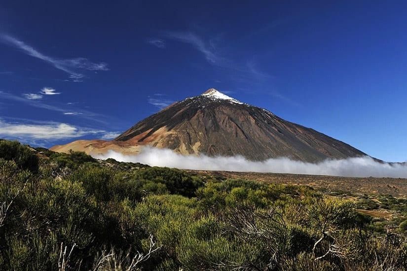
1. Tenerife: the largest island with the highest mountain and beautiful beaches.
With a length of over 80 kilometres and a width of up to 45 kilometres, Tenerife is the largest of the Canary Islands. In terms of landscape, it can be divided into two parts: the green, fertile north, where banana plantations and vineyards adorn the hills, and the somewhat barren volcanic landscape in the south. The biggest icon here is the Pico del Teide volcano, which, at 3,718 metres, is the highest mountain in Spain.
In El Teide National Park, the silhouette of the volcano towers above the petrified lava fields, craters and eroded rock formations in the surrounding area. When climbing El Teide, a cable car takes you up to 3,556 metres. The last part (permit can be requested online) is done on your own, climbing in the thin air, through a true lunar landscape. From the summit, the phenomenal view stretches as far as the island of La Palma, more than 100 kilometres away.
Choose and enjoy between impressive dark volcanic beaches such as Playa Jardin and also the white Beautifull beaches like las Terisitas , El Medano ,Los Cristianos ,Playa las Americas
2. The volcanic mountain landscape of Anaga Rural Park
The Parque Rural de Anaga is located on the extreme north-eastern tip of the island of Tenerife. Here, the mountains rise abruptly from the sea, creating small bays with black sand beaches. The unusual rock formations were created by volcanic activity. Here you will find pointed crater pipes, petrified magma caverns that stand like walls in the landscape, and jagged mountain peaks, often shrouded in a mystical mist.
The subtropical laurisilva, a laurel forest dating back to prehistoric times, stretches out between the volcanic rocks. Take a walk through this humid forest full of whimsical, moss-covered tree trunks of laurel species, willows and wild orange trees. Look for native bird species such as Scopoli's shearwater. It can be found here between February and November and produces an almost whispering sound that fits well with the special atmosphere of this nature park.
3. Auditorio deTenerife: remarkable architecture on the island
In addition to natural beauty and beaches – from the golden yellow Playa del Duque to the jet black Playa del Castillo – Tenerife also has several cities with special attractions. The oldest city, San Cristobal de la Laguna, dates from the late 15th century and is a UNESCO World Heritage Site. The students of the university (founded in 1701), the car-free centre and the many street musicians create a lively atmosphere. A city walk takes you past various colonial buildings, such as the 16th-century Palacio de Nava, whose façade is decorated with balustrades, sculptures and Corinthian columns.
The capital, Santa Cruz, is home to the impressive Auditorio de Tenerife, built between 1997 and 2003. It was designed by architect Santiago Calatrava, who also designed the Ciudad de las Artes y las Ciencias in Valencia. Due to its location on the waterfront, its curved shapes and its white colour (a mix of white concrete and white mosaics), the 58-metre-high building is reminiscent of Sydney's Opera House.
4. Fuerteventura: the Hawaii of Europe
The name Fuerteventura is precisely why windsurfers and kitesurfers love to come here. The island is also known as “the Hawaii of Europe”. Fuerteventura means “strong wind”, which mainly blows on the northern coast of the island. In summer, it mainly comes from the north, with an average speed of 25 to 30 kilometres per hour. Playa Corralejo is popular here. For surfers who like a challenge, Playa Majanicho is highly recommended.
But the island doesn't just attract surfers: beach and sun worshippers also get their money's worth here. Playa la Concha, on the north-west coast, is one of the most beautiful, light-coloured sandy beaches in Fuerteventura. Like the reef off the coast, it is shaped like a crescent moon. An added bonus on this side of the island are the impressive sunsets, where the sky changes from ochre yellow to purple in a matter of minutes.
5. Peaks and ravines in Jandia National Park
Parque Nacional de Jandia is located on the peninsula of the same name in the south of Fuerteventura. Here you will find the Jandia massif, with the highest point on the island: the 807-metre-high Pico de la Zarza. Deep ravines (barrancos) have formed between the mountains on the north side, providing a geological insight into the volcanic past. On the south side, the mountains gradually slope down to the beach.
During a walk, look for the symbol of the park: the cardón de Jandia, a cactus-like plant from the spurge family that only grows on Fuerteventura. The plant grows in clusters and looks like a series of green organ pipes. After your walk, relax on the 14-kilometre-long golden sandy beach of Playa de Cofete, which is also part of the nature park.
6. The shifting sand dunes of Corralejo Natural Park
In the northeast of Fuerteventura, you will find Parque Natural de Corralejo, which stretches along the coast for 11 kilometres and is 2.5 kilometres wide. The nature reserve consists of two different parts: sand dunes that gradually merge into the beaches of Grandes Playas and a desert-like volcanic hinterland. Due to the constant trade winds, the sand dunes are constantly changing shape – so-called “walking dunes”. The landscape looks slightly different every time you visit. Even the road that runs through the dune area is completely covered with sand when the wind is strong.
South of the dunes, the landscape has ochre yellow, black and red tones as a result of its volcanic past. Climb the 314-metre-high cone volcano Montaña Roja for a panoramic view of the dunes, the sea and, on a clear day, the island of Lanzarote, 15 kilometres away. In the morning hours, spot the Canarian collared lark, the flag bearer of the native birds on Fuerteventura.
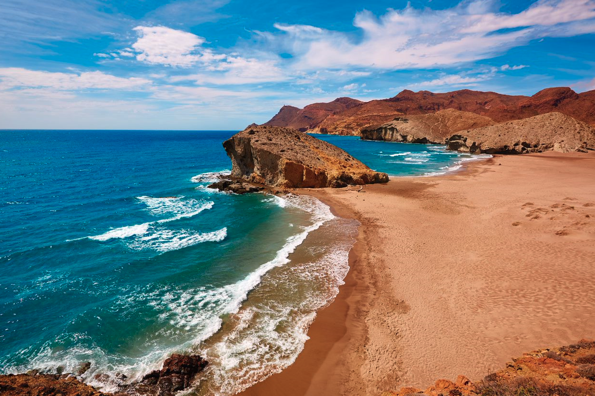
Corralejo village Beach
7. Gran Canaria City Las Palmas de Gran Canaria.
Nestled between two bays and the golden sandy beaches of Playa de las Canteras and Playa de las Alcaravaneras lies the city of Las Palmas, the capital of the island of Gran Canaria. Vegueta, the old town centre, dates back to the 15th century and exudes history. Centuries-old buildings with ornate balconies and wood carvings (including the Gothic Casa de Colón), patios full of plants and multicoloured Moorish tiles, and squares with monumental fountains such as those in Plaza de Santo Domingo alternate with each other.
Stroll along the 4-kilometre-long Canteras city beach, past swimming and surfing spots, to La Puntilla, at the start of the La Isleta peninsula, dotted with volcanoes hundreds of metres high. Here, cross the 300-metre-wide isthmus to the south side of the peninsula to Puerto de la Luz. This is the largest port in Spain, with both a large industrial area and two marinas.
8. Gran Canaria: The summit of Pico de las Nieves
The island of Gran Canaria is shaped like an almost perfect circle, except for a bulge in the northwest. In the middle of the circle lies the Central Massif of Gran Canaria, with its highest point being Pico de Las Nieves: 1,949 metres above sea level. When you approach from one of the coastal regions, the mountains loom up before you, with the second highest peak, Roque Nublo, a striking sight. At its summit, a basalt column rises 80 metres into the air like a warning finger.
From all directions, narrow roads wind their way up. Along the way, you will see small villages, terraced fields and ravines. In the lower regions, exotic vegetation, including almond trees, cacti and eucalyptus trees, covers the landscape. As you climb higher into the mountains, these are replaced by pine trees, holm oaks and lower shrubbery. At the top, you have a panoramic view, often mixed with an underlying blanket of clouds, above which the peaks of the neighbouring island of Tenerife rise.
9. Gran Canaria Desert and oasis in the south
Between the popular beaches of Playa del Ingles and Maspalomas in the south of Gran Canaria lies the Dunas de Maspalomas nature reserve. This dune area moves an average of 1 metre per year to the southwest under the influence of the wind. When you look around you in the middle of the Dunas de Maspalomas, all you see are rolling sand dunes, up to 10 metres high. Spot the footprints of giant lizards and geckos in the sand, alongside your own.
In addition to sand dunes, this nature reserve also includes the Charco de Maspalomas lagoon. The lagoon, with brackish water and reed beds at the edges, is a popular resting place for migratory birds travelling between Africa and Europe. Spoonbills, sanderlings and curlews are among the frequent visitors here. Next to the lagoon lies the El Palmeral oasis, a palm forest where several hotels are located.
10. Lanzarote The cultural heritage of César Manrique
While in Lanzarote, take a look at the Fundación César Manrique museum. This artist (1919-1992) – born on this island – produced a wide range of work: from paintings and sculptures to (landscape) architecture. He aimed to create art in balance with the surrounding nature. Manrique is regarded as the contemporary patron saint of Lanzarote because he ensured that the island retained its authenticity (few advertising hoardings, no high-rise buildings and only traditional colours) and did not succumb to mass tourism.
The Fundación is located in his former home, integrated into a lava field. He built rooms in the natural caves and mosaics and cacti alternate in the garden. Elsewhere on the island, he created Jameos del Agua, a geological park landscape, where an auditorium has been built in a volcanic tunnel with an artificial lake outside. And at Mozaga stands the white sculpture Monumento al Campesino, depicting a farmer with a donkey and a dromedary, in memory of the island's agricultural past.
11. Lanzarote Timanfaya National Park: the rugged part of the island.
For the wildest part of Lanzarote, head to Timanfaya National Park. Here you can clearly see how the forces of nature not only shaped the island in its early days, but also influenced it later on, when it was already cultivated and inhabited. Between 1730 and 1736, several devastating eruptions took place, wiping eleven villages off the face of the earth. The nature reserve is named after the first village to fall victim to this.
Hop on the park bus from the car park at El Diablo, the only way to visit the park. The journey takes half an hour and along the way you will see 25 craters and over 100 volcanic cones. Getting out is not allowed, because the earth here is still boiling hot. At the car park, this heat is demonstrated in various ways: water poured into tubes immediately comes out as steam and a bunch of straw placed on an opening immediately catches fire. Volcanism in practice!
12. The lava caves of Cueva de los Verdes
During the last eruption of the Corona volcano, approximately 4,000 years ago, flowing lava came into contact with the colder seawater, creating the Cueva de los Verdes cave system. The cave system is located in the northeast of Lanzarote and consists of a network of caves and passages with a total length of 7 kilometres.
Accompanied by a local guide, you can explore the 1-kilometre-long section of the cave system that is accessible to the public in just under an hour. The passages vary greatly in height and width. You will regularly have to duck to avoid bumping your head. Along the way, you will see small pools and enter an underground auditorium, a natural space with excellent acoustics, where concerts are occasionally held. Also striking are the so-called lava drops that hang from the ceiling here and there. These were created by the rapid cooling of the lava by the cold seawater.
13. La Palma: La Isla Bonita /The Beautiful Island
The nickname "La Isla Bonita" (the beautiful island) sets a high bar for visitors to La Palma. It's the most northwesterly of the Canary Islands and also the greenest of the group. Mass tourism is hard to find here, but hiking enthusiasts know their way around the island. A network of hiking trails through volcanic landscapes, ravines, and laurel forests connects the island's picturesque villages—including San Andres and Santa Cruz.
Parque Nacional Caldera de Taburiente is a popular hiking destination. The park's namesake is the Taburiente crater (10 by 5 kilometers), with steep surrounding walls and the 730-meter-high Idafe rock in the middle. Via the hiking trail along the Rio Almendro Amargo, you can reach the Los Colores waterfall. The iron-rich water has colored the rock red and yellow in some places, while in others, green moss covers the dark lava rock. From Mirador del Lomo de Tagasaste, you have a beautiful overview of the crater.
14. La Gomera The whistled language in the mountains of the island of La Gomera.
While hiking through the laurel forests of Garajonay National Park or enjoying the mountain views from the approximately 1,200-meter-high Los Roques, you might be startled by a symphony of whistles. It's a strange sensation. This is the unique whistled language of the island of La Gomera: El Silbo Gomera, which originated in the 15th century. By whistling in all sorts of tones with a bent finger in the mouth, it's possible to communicate across a distance of 3 kilometers.
The island's geography, with mountains up to 1,500 meters high interspersed with caves and valleys, forced residents to develop an alternative language to reach each other. Not a spoken language, but a whistled one. Since the invention of the mobile phone, the necessity has diminished and fewer people "speak" this language. It's now mainly used for demonstrations. However, since the late 1990s, it has become a school subject and has been declared an intangible cultural heritage by UNESCO.
15. El Hierro ,The best island for one of Europe's best dive spots.
The smallest of the seven "major" Canary Islands, El Hierro, is geographically sized somewhere between the Dutch islands of Schiermonnikoog and Vlieland. The landscape is primarily shaped by a series of volcanoes with peaks up to 1500 meters high, dark basalt rock, solidified lava flows, and juniper trees. Since the coast consists almost entirely of mountains that end steeply in the sea, there are only a few small beaches, all located around the town of La Restinga in the south. Fun fact: this is also the southernmost part of Europe.
El Hierro mainly attracts people seeking tranquility, hikers, and divers. The latter group comes for the Mar de las Calmas marine reserve and the surrounding area near La Restinga. This is considered one of the best dive spots in Europe, especially around El Bajon: an extinct underwater volcanic mountain with slopes that drop to 100 meters. Here, you share the underwater world with creatures such as moray eels, trumpetfish, whitetip sharks, and, with a bit of luck, manta rays.
---------------------------------------------------------------------------------------
Well-known places in the Canary Islands
Where can you find the most beautiful seaside resorts?
We have listed the most important seaside resorts for you:
Tenerife: Costa Adeje, Arona, Playa las Americas, Playa los Cristianos and Costa de Silencio – Tenerife
Gran Canaria: Playa del Inglés, Arguineguin, Maspalomas and Puerto Rico
Fuerteventura: Corralejo
Lanzarote: Costa Teguise
If you are looking for more entertainment and hustle and bustle, the larger islands such as Tenerife or Gran Canaria may be more to your liking. If you are looking for more peace and quiet, La Comera, Fuerteventura or Lanzarote may be more suitable. Experience it for yourself!
Thank you for your Attention.
CB Immo Broker Always at your service.
Spanisch Costa,s
Discover the breathtaking beauty of Spain's diverse Costas, each...
more
The most Beautifull sights of the Balearic islands
The most Beautifull sights of the Balearic islandsGet ready to...
more
The positive of Bali
https://storage.googleapis.com/static.inmoweb.es/clients/3625/cms/image-25.jpgThe positive of Bali Bali is a premier global destination offering a blend of rich Hindu culture, stunning...
more%2010.14.12.png)
Why Invest in the Canary Islands
Why invest in the Canary IslandsThe Canary Islands are an archipelago of islands off the west coast of Africa, and are therefore located in the Atlantic Ocean.Contrary to what is often mistakenly...
more